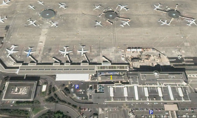
POINT 1CURRENTLY CLOSED UNTIL FURTHER NOTICE DUE TO CONSTRUCTION WORK
Although the well known terrace has been closed some years ago to give room for the new West Wing Terminal, there is still an official place in the main building to take pictures. It is a balcony located at the last level of the « Restaurant » building.
This terrace is glassed (which makes photography complicated by rainy weather) but it allows good view of the main ramp.
Aircraft sometimes pass quite far away, but pictures of aircraft parked at the satellites or taxying on both inner and outer taxiways are possible.
This place is at its best during the morning, when the sun shines from behind. It is possible to buy drinks and snacks from the bar as well, but they are expensive. A visit to the Migros supermarket (open daily 0800-2000) at the airport railway station will make the stay cheaper. Access to the terrace is free of charge, but it can be closed in case of severe weather conditions.
There are several different points around the airport which offer very good possibilities for photography. Here is an explanation on how to reach them from the terminal by foot or bicycle. For those visiting by car, parking aereas are displayed on the following pictures as well (please respect the No Parking signs !)
RUNWAY 23 IN USE (landing from lake side)
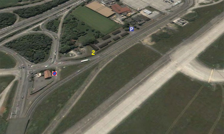
POINT 2NO LONGER AVAILABLE DUE TO NEW RAMP BEING BUILT -- POSITION LOST
Exit customs and go up one level: you will arrive at the Departure floor. Go out of the main building and turn immediately left. You will see the railway station ("Gare CFF"). Walk in that direction, pass the railway station on its left side (you can use the small bridge with ground painted in red that goes between the railway station and the brown building "Swissair + Iata Centre"). Then you will arrive at a very long building called "Geneva Arena": walk along this building on its left side again, so as to have a first view at one of the airport's apron. At the end of the building, the street goes down and turns slightly to the left (under a newly built exposition hall of the Geneva Palexpo fair complex), follow it and pass along the Cargo terminal ("Fret"). At the end of this long building, the street curves to the left and to the right again. Then simply follow the airport fence.
Do not cross the large parking lot instead, the gate at the exit might be closed !!!
At one moment, after having passed a small chemical plant you will notice on the right side of the street wooded brown houses. This is an inoffensive military camp, and if you climb the hill you will be ideally placed to take pictures (no need for a ladder).
This place is shown as « Point 2 » on our aerial view and is the best place for pictures in Geneva during mornings, and many pictures on our website are taken from this place. The light is good till around 1400.
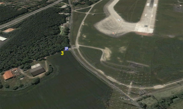
POINT 3
An alternative position, shown as « Point 3 » on our aerial view allows approach pictures (but no line ups are possible).
A new road has been built that now eases access from « Point 2 » to this place along the infamous corrosion corner where a group of old (non-) airworthy Gulfstream IIIs are parked. Follow this road until you reach the Chemin des Clys, shortly before the approach lights. There is enough place to park your car here.
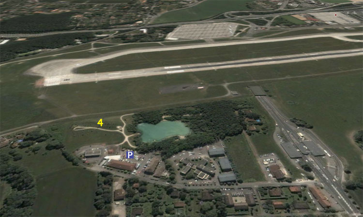
POINT 4
When the sun turns slowly to the north side of the runway (at around 1500-1600 during summer), cross the tunnel that you will have noticed some 100m to the right of« Point 2 ». Prepare your passport (!) as the other side of the airport is in France !
Then follow the first road going to the right (leading to "Foyer Schweitzer"). 250m further is a "Lidl" supermarket from where you will see a large hill with banks and trees.
This is an ideal place for pictures during the afternoon for both landings and line ups. You also have the Alps in the background. There is no need for a ladder here either. But you need an official permit if you want to fish in the small lake !
Walk to « Point 2 » is around 20 minutes, 15 more to « Point 3 » or « Point 4 » respectively.
Accomodation in Geneva
Follow the link to the Geneva Tourism Office which provides a complete list of hotels in the city classified by categories.
Price standards in Switzerland are relatively high compared to the rest of Europe. So it is with accomodation rates as well. Geneva airport is located on the border with France where prices are lower, and it could be interesting to check out for French hotels in addition to those given by the link above.
Two of them are located just on the other side of the border (and therefore considered as Airport Hotels as well) : These are the Novotel, and just meters away the Formule 1 Motel. To reach them from runway 05, continue driving northbound
towards Mategnin, turn right and follow signs indicating Ferney-Voltaire. Once you have crossed the border the two hotels will appear at the next roundabout. Except for the Novotel airport shuttle leaving from the airport, there is no public transportation to these hotels : you will need a car to reach them.
Hotels in Geneva City are easily accessible by train or bus (line 10 from terminal, line 9 southbound from runway 05 and lines 18 or F southbound from runway 23). All lines, except 18, stop at or next to Geneva main railway station downtown (18 serves Carouge, an interesting and historical suburb with animated nightlife).
Caution : several big fairs take place seasonally at the Geneva Palexpo building next to the airport. The International Car Show (first half of March) to name one. During these events Geneva hotels are usually fully booked long in advance !
Accomodation information are given for assistance purpose only and DPTS Association cannot be held responsible in any circumstance in matters resulting from the use of any of the above mentionned links.
Geneva ATC Frequencies
These are the major ATC frequencies in use in Geneva:
Tower 118.700Delivery 121.675Taxi 121.750Departure 119.520Arrival 136.250Final 120.300Terminal 119.525Jet Aviation 130.650ATIS 135.575MetBroadcast 126.800
In Switzerland use of radios to listen to ATC conversations is permitted.
Pictures copyright Information:
All Satellite pictures contained on this page are (c) DigitalGlobe 2005
Pictures adaptation to the context of this Website (c) DPTS Association - 1999-2006
Public transport network extract (c) TPG Transports Publics Genevois 2007
DPTS Association is grateful to anyone sending contributions to this website.
We apologize in advance in case of unfortunate mistakes.
(c) DPTS Association - 1999-2008
Last update: 6 December, 2016
click to go on top
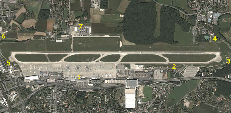
Geneva Airport is located five kilometers north of downtown which makes it a real city airport. Its construction began in 1920 and even though it will soon reach ten million passengers per year, it only has one single concrete runway (and a parallel grass runway for light aircraft). Geneva Airport has the particularity of lying just south of the French border (the forest on the above picture is in France) and has a dedicated French terminal. Geneva's aviation enthusiasts sometimes have to cross the border to take pictures of airplanes landing on Switzerland's second largest airport ! But local citizens are used to these border crossings and will have to remain for a long time since Switzerland will not become an European Union member for the foreseeable future.
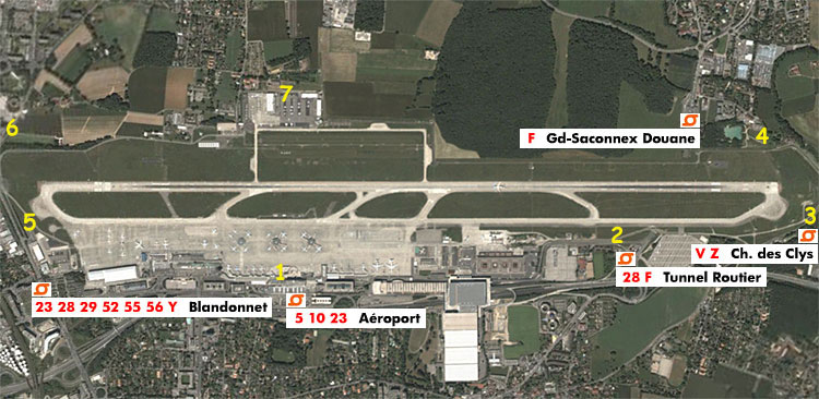
The most used places for aviation photography are indicated by yellow numbers on the aerial view above:
Pass your mouse on the number of your choice to view an example of pictures you can take at this place
Click on the number of your choice to be directed to a zoomed picture of the place, with desciption on how to reach it and car parking possibilites. View same picture with public transport stops.
Information about Hotel accomodation as well as ATC frequencies are available at the bottom of this page.
RUNWAY 05 IN USE
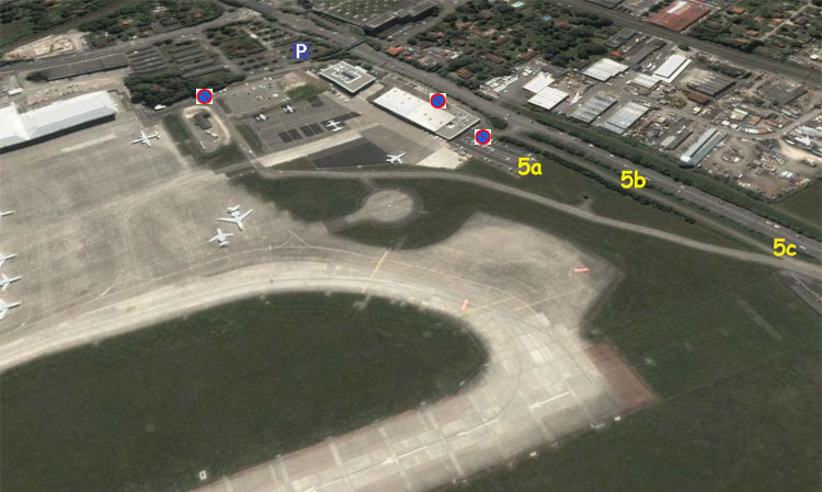
POINT 5
From the terminal turn right this time, pass between the new grey terminal and the green World Trade Center. You will pass by the Tower and a large parking lot. Then the street curves to left and the right again. Still follow it, pass an employee gate next to the large maintenance hangar and then turn right, and follow the bicycle track that climbs steeply.
Then you will see the airport fence again. At the right you can have a look at the large apron mostly used by bizjets and some cargos.
Go left, pass around the newly built executive terminal and follow the bicycle track. This place has a changed somewhat, but for the better. Line up pictures can be taken from inside the Tag Aviation parking lot, through the fence (5a). Ladders are of no use since a barblewire has been installed at the top of the fence. Approaches pictures can be taken either from inside this parking lot, or from the bicycle track (5b) as before. For afternoon line ups pictures, you have to walk further down the bicycle track (5c).
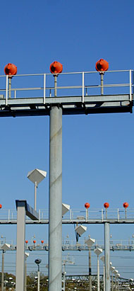
At this place pictures are taken through the fence. There are small holes in it, but a ladder or a bicycle to climb on can be helpful, especially if aircraft have to turn into the holding bay before line up. There is no barbelwire at the top of the fence here, as it would intefere with the ILS installations.
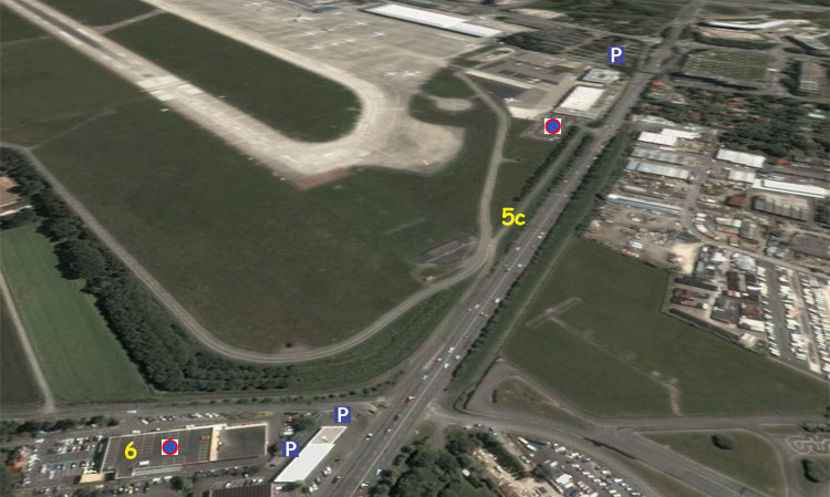
POINT 6
For approaches in the evening walk some 200m more to « Point 6 » which is the roof of the Nissan building. Please do not park your car on the roof since this parking lot is reserved to the guests of the restaurant located in the same building. There are parking spaces at the gas station. The walk to this side of the airport is a bit shorter than when the runway is used the opposite way.
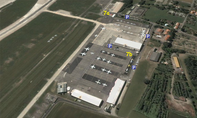
POINT 7
You can also have a look at the General Aviation apron which is located on the northern side of the airport (« Point 7 »). It is easy to reach from « Point 6 » by following the street towards Meyrin and by turning right at the « Jaillat » car sale office. From there you can take pictures of aircraft entering or leaving the apron from place (7a) which is an open air restaurant, or have a general look at the main tarmac by driving along the fence at place (7b).
Access with Public Transport
Bus stops located next to photo points around the airport are indicated with this symbol:
Click on it to open Geneva Public Transportation website and have access to accurate network and schedules information.
Letter / Number next to the symbols on our picture represent bus line (sometimes more than one serves each stop) followed by exact stop name. There are additionnal stops between those indicated. Follow the above indicated link for additionnal info.
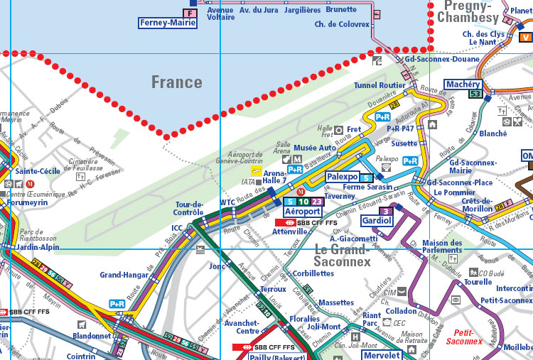
The following map is an extract of the network focusing on the Airport area.